
The Basics of GPS Coordinates
The Global Positioning System, or GPS, is a technology that has become ubiquitous in our everyday lives. From navigating while driving to finding our way on a hiking trail, GPS is a powerful tool that helps us determine our location, direction, and speed. At the heart of GPS are GPS coordinates, which are the foundation of the system. In this article, we’ll explore the basics of GPS coordinates and how they work.
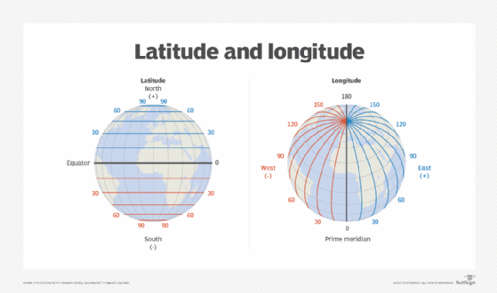
GPS coordinates are a set of numbers that represent a specific location on the Earth’s surface. The Earth is divided into a grid of latitude and longitude lines, which provides a global standard of location reference. The lines themselves are measured in degrees, with the equator serving as the starting point for latitude and the prime meridian serving as the starting point for longitude. Latitude ranges from 0 to 90 degrees, with the equator being 0 and the poles being 90. Longitude ranges from 0 to 180 degrees, with the prime meridian being 0 and the international date line being 180.
To determine a location on the Earth’s surface, we need to specify a combination of latitude and longitude. This can be done in several different coordinate formats, but the most common are decimal degrees and degrees-minutes-seconds (DMS).
Decimal degrees are the simplest form of coordinates and represent a location’s latitude and longitude in decimal form to six decimal places. For example, the coordinates for the Eiffel Tower in Paris, France in decimal degrees are 48.858523, 2.29452.
DMS coordinates, on the other hand, represent a location’s latitude and longitude in degrees, minutes, and seconds. For example, the coordinates for the Eiffel Tower in DMS format are 48°51’24.684″N, 2°17’40.272″E. In this format, the degree symbol (°) represents whole degrees, the apostrophe (‘) represents minutes, and the double quote (“) represents seconds.
To use GPS coordinates, we need a GPS device that can receive signals from GPS satellites orbiting the Earth. These satellites transmit signals that are picked up by GPS receivers, which use the signals to determine our location using a process called trilateration. Trilateration involves measuring the distance between a GPS receiver and a minimum of three GPS satellites. By measuring the time it takes for the signals to travel between the satellites and the receiver, the GPS device can calculate the distance to each satellite and use this information to determine its location on the Earth’s surface.
In conclusion, GPS coordinates are a critical component of the navigational system we use every day. Understanding the basics of how GPS coordinates work is essential for using GPS effectively and exploring the world around us. Whether you’re hiking through the wilderness or driving to a new city, GPS coordinates provide a precise and reliable way to navigate and explore our amazing planet.